Taal Volcano is a
complex volcano on the island of
Luzon in the
Philippines. It is situated between the towns of
Talisay and
San Nicolas in
Batangas. It consists of an island in
Lake Taal, which is situated within a
caldera formed by an earlier, very powerful eruption. It is located about 50 km (31 miles) from the capital,
Manila. It is one of the
active volcanoes in the Philippines, all part of the
Pacific ring of fire.
The volcano has erupted violently several times, causing loss of life in the populated areas surrounding the lake, the current death toll standing at around 5,000 to 6,000. Because of its proximity to populated areas and eruptive history, the volcano has been designated a
Decade Volcano worthy of close study to prevent future
natural disasters. It was thought to be named as "a volcano inside a volcano" because many believed that the lake that circles the volcano was once a crater or mouth of a volcano.
The
Batangas province towns along the shores of Taal Lake include
Tanauan,
Talisay, Laurel, Agoncillo, San Nicolas, Santa Teresita, Alitagtag, Cuenca,
Lipa, Balete and Mataas na Kahoy. The extinct crater on Volcano Island is also visible along high property value Tagaytay Ridge for visitors coming from Manila or enroute the Batangas coast and ports to the South.
Current activity
Although the volcano has been quiet since 1977, It has shown signs of unrest since 1991, with strong seismic activity and ground fracturing events, as well as the formation of small
mud pots and mud
geysers on parts of the island. The
Philippine Institute of Volcanology and Seismology (PHIVOLCS) regularly issues notices and warnings about current activity at Taal, including ongoing seismic unrest.
 |
| Aerial photo of Taal Volcano; North is on right-hand side of photo. |
Previous activity
There have been 33 recorded eruptions at Taal since 1572. One of the more devastating eruptions occurred in 1911, which claimed more than a thousand lives. The deposits of that eruption consisted of a yellowish, fairly decomposed (non-juvenile) tephra with a high sulfur content.
2009
20 July. National Disaster Coordinating Council (NDCC) NDCC executive officer Glenn Rabonza warned that although there were no volcanic quakes detected at Taal since the detection of nine volcanic quakes from June 13 to July 19, and there had been no steaming activity monitored since the last recorded on June 23, Phivolcs Alert stands at Level 1, warning Taal’s main crater is off-limits to the public because steam explosions may suddenly occur or high concentrations of toxic gases may accumulate.
2008
28 August. PHIVOLCS notified the "public and concerned authorities" that the "Taal seismic network recorded ten (10) volcanic earthquakes from 5:30 A.M. to 3P.M. today. Two (2) of these quakes that occurred at 12:33 and 12:46 P.M. were both felt at intensity II by residents at barangay Pira-piraso. These quakes were accompanied by rumbling sounds. The events were located northeast of the volcano island near Daang Kastila area with depths of approximately 0.6km (12:33 P.M.) and 0.8km (12:46 P.M.)"
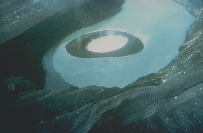 |
| Cinder cone in the acidic crater lake |
Taal Volcano Eruptions
1977, 1976, 1970, 1969, 1968, 1967, 1966, 1965, 1911, 1904, 1903, 1885?, 1878, 1874, 1873, 1842, 1825, 1808, 1790, 1754, 1749, 1731, 1729, 1716, 1715, 1709, 1707, 1645, 1641, 1635, 1634, 1609, 1591, 1572.
Taal Volcano Eruptions 1572-1911 Timeline graph of Taal Volcano Eruptions from 1600-2010
The most recent period of activity lasted from 1965 to 1977, and was characterized by the interaction of magma with the lake water, which produced violent
phreatic explosions. The 1965 eruption in particular led to the recognition of
base surge as a process in volcanic eruption (due to the fact that one of the American geologists, who visited the volcano shortly after the 1965 eruption, had witnessed an atomic bomb explosion when he was a soldier). The eruption generated base surges and cold
pyroclastic flows, which traveled several kilometers across Lake Taal, devastating villages on the lake shore and, killing about a hundred people. The population of the island was evacuated only after the onset of the eruption. Precursory signs were not interpreted correctly until after the eruption. Eruptions in 1968 and 1969 were characterized partly by Strombolian activity and produced a massive lava flow that reached the shore of lake Taal. The 1977 eruption merely produced a small cinder cone within the main crater.
Taal Volcano is part of a chain of
volcanos along the western side of the edge of the island of Luzon, which were formed by the
subduction of the
Eurasian Plate underneath the
Philippine Mobile Belt. Taal Lake lies within a 25–30 km caldera formed by four explosive eruptions between 500,000 and 100,000 years ago. Each of these eruptions created extensive
ignimbrite deposits, reaching as far away as where
Manila stands today.
Since the formation of the caldera, subsequent eruptions have created another volcanic island, within the caldera, known as Volcano Island. This island covers an area of about 23 km², and consists of overlapping cones and craters. Forty-seven different cones and craters have been identified on the island.
Coordinates:  14°0′7″N 120°59′34″E


