 |
| Binubulauan viewed from the village of Bangtitan, Upper Uma, Kalinga Province, active volcano of the Philippines Location : Codillera Central, Kalinga, Philippines Elevation : 2,329 m (7,641 ft) Type : Stratovolcano Age of rock : Holocene Volcanic arc/belt : Cordillera Central Volcanic Arc Last eruption : 1986 |
- Name Binuluan, Co-ordinates N 17°15' E 121°08', Province Kalinga-Apayo, Region Cordillera Administrative Region, Elevation 2329 meters ASL.PHIVOLCS also lists Ambalatungan at almost the same location.
- The Smithsonian Institution's Global Volcanism Program does not list Binubulauan separately but includes Binuluan as a cone subfeature in the listing for Ambalatungan:
- A little-known cluster of volcanoes in the Cordillera Central of northern Luzon is known as Ambalatungan by Alvir (1956) and the Philippine Commission of Volcanology (1981) and as Mount Binuluan by Wolfe (1982, pers. comm.). The dacitic Ambalatungan Group was described as consisting of three volcanoes constructed along a roughly E-W line. Ambalatungan volcano proper contains a steep-walled crater with hot springs and vigorous sulfur-encrusted fumarolic vents that produce loud noises. Bumabag volcano, 3 km east of Ambalatungan, has two craters that also show strong fumarolic activity. Podakan volcano, 1 km SE of Bumabag, also has a large steam vent. A possible steam eruption was reported from 2329-m-high Mount Binuluan (whose relationship to the previously mentioned volcanoes is unclear) in 1952, during which a sulfur-rich debris flow killed a dozen people.[
 |
| Sugo-oc Fumarole Field |
In October 2007 the Sugo-oc fumarole field was sighted and photographed from the opposite (southern) side of the Bunog River valley, on the Tinglayan Tulgao road. Unfortunately mist, cloud, and intermittent rain precluded any clear photo, and heavy rain on the return journey the next day prevented all photographing.
An on-site investigation was planned for the dryer season in April-May 2009, with access through Sumadel rather than Tulgao or Dananao, but had to be abandoned due to an escalation in the border dispute between the Tinglayan tribe and the Tulgao tribe.
 |
| Bum-bag Fumarole Field |
Bum-bag fumarole fields (Balatoc dialect), (or Djum-ag in Upper Uma dialect), are located approximately 3 kilometres east of Bu-ot, on Batong Buhay tribal land. Pronunciation is closest to boom-bug in English, with boom pronounced like look.
Bum-bag is on the eastern side of the Pasil river valley at an elevation of about 1437 metres above sea level.
Bu-ot Fumarole Field
The Bu-ot Fumarole Field (Balatoc dialect) is located on the western valley side above the Pasil River, immediately below the village of Balatoc, on Balatoc tribal land.
 |
| Bu-ot Fumarole Field |
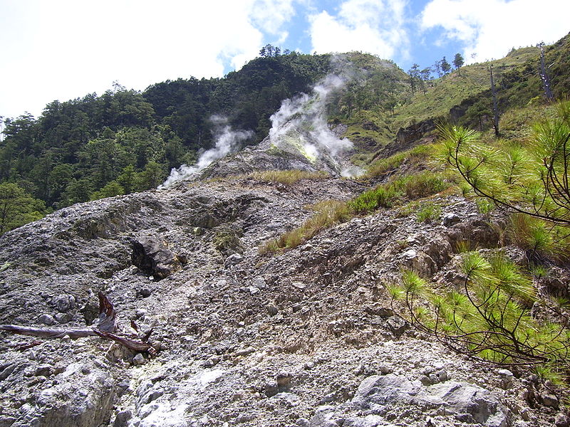
It is beside the Pasil River on the steep western valley wall, with the path to Balatoc village immediately to the right of the fume hole field. When the photos were taken on 20 April 2008, there were two active steam vents with yellow water flowing from the vents, as well as from some other locations in the field, down to the Pasil River. The rocks of the Pasil River are heavily stained orange-yellow both upstream and downstream from the Bu-ot fume hole field.It is beside the Pasil River on the steep western valley wall, with the path to Balatoc village immediately to the right of the fume hole field.
Bu-ot is steep-sided but is not a crater.
In 2008, residents of Balatoc did not know of any place called Ambalatungan. However, it is suggested Bu-ot is the area the Smithsonian description calls Ambalatungan. Primary reason for suggesting this is because of the location of the other two fumarole fields in the valley in relation to this field, and the absence of any other fume hole field in the relevant area.
Eruptions
In 2007 and 2008, ninety and one hundred year old elders in Tinglayan and Tulgao said the loss of life in 1952 was caused by an eruption during a typhoon with the collapse of a natural earth bank below Sugo-oc fumarole field, high on the northern side of the Bunog River valley, with the consequent mudslide burying a few houses below and killing maybe 12 people or thereabouts.
Sugo-oc is on the southern flank and is largely inaccessible from the northern and western flanks of Binubulauan. Also Sugo-oc is not mentioned by name or description in the Smithsonian's listing. If information about the 'eruption' had been originally obtained from the Pasil River valley people, there could have been some difficulty in explaining to non-Kalingan people the precise location of the fatalities and their cause in a different, unconnected, valley.
In 2007 and 2008, people in southern Kalinga around Binubulauan spoke of an 'eruption' at Sugo-oc in 1986 or 1987. During the Abra earthquake at 20:16 hours on Sunday 13 January 2008, buildings in Tinglayan shook and windows rattled for about 10 seconds. When speaking in English, the locals there at the time called this an 'eruption'. Gentle questioning of locals over months led to the conclusion that there are difficulties in communicating the difference between an eruption and an earthquake.
Further inquiries in southern Kalinga in December 2008 - January 2009 resulted in reports that there was an earthquake in 1986 which was felt throughout Labuagan Municipality and Tinglayan Municipality, and at the same time there was an eruption at Sugo-oc resulting in the ejection of ash and rock from Sugo-oc. Three people in Dananao village were killed by ejected rock during this eruption. Because of the eruption and deaths, there was a large migration out of Dananao village with the Dananao people taking possession of land on the Tubuk to Aurora road in eastern Kalinga and resettling there. Further details will be sought during a field expedition to Dananao and Sugo-oc when current intertribal unrest decreases.
Details about the eruption in 1952 are still scant. There may have been an eruption or there may have been a lahar at the Sugo-oc sulfur fumarole field located near the villages of Dananao and Sumadel, with loss of some dwellings and about 12 lives. There was a projectile eruption at the same location in 1986 killing three people.
In 2009, the Sugo-oc fumarole field is still active.
| Coordinates | 17°18′40″N 121°06′13″E / 17.310982°N 121.103668°E |
|---|